


le truel

CASSISFRAMBOISE
User
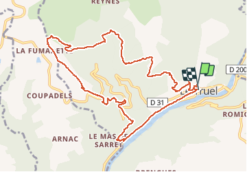

Length
12.2 km

Max alt
729 m

Uphill gradient
528 m
Km-Effort
19.3 km

Min alt
265 m

Downhill gradient
540 m
Boucle
Yes
Creation date :
2021-01-08 08:15:12.874
Updated on :
2021-01-08 13:40:56.106
4h12
Difficulty : Easy

FREE GPS app for hiking
 SityTrail
IGN / Geographical institutes
SityTrail Plus
The world is yours!
About
Trail Walking of 12.2 km to be discovered at Occitania, Aveyron, Le Truel. This trail is proposed by CASSISFRAMBOISE.
Positioning
Country:
France
Region :
Occitania
Department/Province :
Aveyron
Municipality :
Le Truel
Location:
Unknown
Start:(Dec)
Start:(UTM)
480362 ; 4877483 (31T) N.
Comments